

What is Geoinformatics?
Geoinfomatics
(From http://gis.sis.pitt.edu/ )
What is Geoinformatics?
Geoinformatics encompasses a collection of special techniques, technologies, and tools for the acquisition, processing, management, analysis, and presentation of geospatial data. Geoinformatics is based on a range of synergetic activities including geospatial modeling, geospatial analysis, geospatial databases, geospatial technologies, information systems, systems design, spatial cognition, human-computer interaction, mobile computing, wired and wireless network technologies. Today, numerous applications are benefiting from geoinformatics techniques, technologies, and tools and with recent advances in geoinformatics and related technologies, such as Web services and grid computing, new geoprocessing paradigms and applications are expected to emerge. go to Wikipedia for more…
Geoinformatics Layers
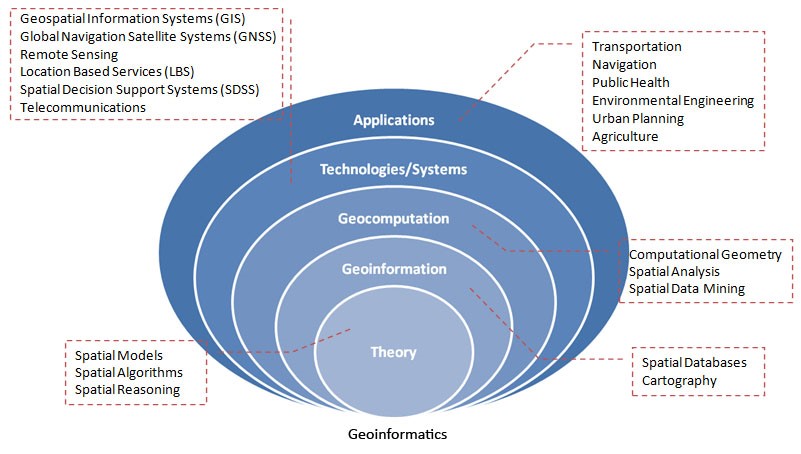
Interdisciplinary Fields of Geoinformatics

Geoinformatics Disciplines: This diagram shows Geoinformatics as an inter-disciplinary field. It includes techniques and methodologies from information sciences, computer sciences, cognitive sciences, telecommunications, and geomatics.
Location Based Services (LBS) Concept Diagram
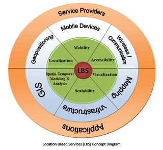
Location Based Services (LBS) Concept: This diagram illustrates the concept of LBS as viewed by our lab. At the center core is the idea of LBS. The first ring (green) represents concepts involved within the study of LBS. The second ring (blue) represents technologies that are associated with the underlying concepts. The outer ring (orange) illustrates how users access LBS, through both the service providers and applications which may use an application programming interface (API).
Navigation Concept Diagram

Navigation Concept: This diagram illustrates the concept of navigation as viewed by our lab. Starting with the User entity, the User provides their location via geopositioning technologies (GPS, IP-to-Address, etc.). The user also makes a request for a route/direction to get somewhere. The Location that was originally provided is used in determining the route to establish a starting point. The Route entity also requires the network entity (a road network in the case of car navigation systems) in order to determine the route to follow within the network. These Route and Network entities are presented through a Visualization entity, usually the Route is overlayed on the underlying Network. This Visualization is then ultimately presented back to the User to provide them a means for navigation.
References
Geoinformatics Laboratory, University of Pittsburgh: Location Thinkers. http://gis.sis.pitt.edu/
Karimi, H. A. (Ed.) Big Data Techniques and Technologies in Geoinformatics, Taylor & Francis (2014).
Karimi, H. A. (Ed.) Advanced Location-Based Technologies and Services, Taylor & Francis (2013).
Karimi, H. A. Universal Navigation on Smartphones, Springer (2011).
Karimi, H. A. and Akinci, B. (Eds.) CAD and GIS Integration, Taylor & Francis (2010).
Karimi, H. A. (Ed.) Handbook of Research on Geoinformatics, IGI Global(2009).
Karimi, H. A. and Hammad, A. (Eds.) Telegeoinformatics: Location-Based Computing and Services, Taylor & Francis (2004).